Re-evaluation the polders from Danube Floodplain and Delta

Type 1 & 2 & 3 NBS
NBS info
| Country | Romania |
| River, water body | Danube Delta |
| Stage | IN |
| Size | Large |
| Geotype | National |
| Innovative Solutions |
 |
 |
 |
 |
 |
 |
 |
|
|
Project summary
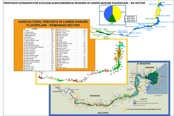
The ecological and economical Program of re-evaluation the polders from Danube Floodplain and Delta was conceived and launch to give assistance to the Romanian Government in the process of strategically long-term planning for fulfilling the goals of the Water Framework Directive as well as for effective implementation of tasks regarding prevention, protection and mitigation of flooding effects, stipulated in the National Strategy for Flooding Risks Management. The main objective of the program was to create the strategy of implementation of the integrated management concept (adaptative and ecosystemic) and sustainable development in Lower Danube Floodplain– Romanian Sector and also to elaborate priorities and criteria which show the ecologic, economic and social interests in order to evaluate the necessary and available resources, in order to increase the projects viability.
Best practices and references
Stipulated results:
Environmental, socio-cultural, economic impacts
In the same time the program “Ecological and economical restoration of Lower Danube floodplain – Romanian sector” in order to implementing National Strategy of Management regarding Flooding Risk is in connection with European Union Directives (Water Framework Directive, Directives regarding Natural Habitat’ Conservations, Wild Flora and fauna, Birds Conservations ), and also the Objectives of Natural Strategy for Sustainable Development. Danube River and its Valley in the Romanian Sector represented the subject of researchers for arrangement of the floodplain in order to its economical valorization, most of them stopped in 1970. With the view of implementing this Program, it insist on knowing at detailed level, the state of socio-economical and ecological systems, elaboration of digital model of the land and also hydraulic model, without can’t be possible elaboration of the strategy against flooding.
Replication and scalability
The entire project, with the generated objectives and issues, contributes to:
Participation process
The diversity of the fields addressed through the imposed theme determined permanent meetings between partners to achieve a unique methodology in addressing these diverse topics, but also good information in the fields: remote sensing, soil quality, hydrology, economy and environmental protection.